Showing 107 items matching 1950's house
-
 Whitehorse Historical Society Inc.
Article, Splashing Out In Colour, 2001
... and article on the renovation of their 1950's Forest Hill... on the renovation of their 1950's Forest Hill house.... of their 1950's Forest Hill house. and article on the renovation ...Article with photo of the Reed FamilyArticle with photo of the Reed Family and article on the renovation of their 1950's Forest Hill house.Article with photo of the Reed Family reed family, forest hill, weatherboard, forest hill chase -
 Whitehorse Historical Society Inc.
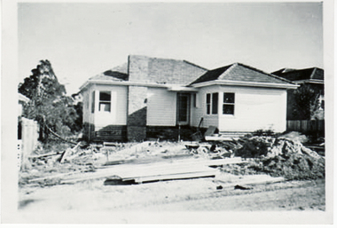
Photograph, Building Turner Home - 27 Salisbury Street, 1956
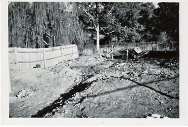
... 1950's house.... salisbury avenue blackburn no 27 1950's house ...Collected at a Heritage Week Workshop at Blackburn Library on 5th October 2009.Black & white photograph of the Turner home being built in Salisbury Street Blackburn on 15 April 1956.salisbury avenue blackburn no 27, 1950's house -
 Whitehorse Historical Society Inc.
Photograph, Turner Home in Salisbury Ave Blackburn, 1957
... 1950's house... no 27 1950's house road making ...Collected at a Heritage Week Workshop at Blackburn Library on 5th October 2009.Black & white photograph Turner home at 26 Salisbury Ave Blackburn showing a series of views of the making of the road in June 1957salisbury avenue blackburn no 27, 1950's house, road making -
 Whitehorse Historical Society Inc.
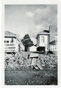
Photograph, Turner Home in Salisbury Ave Blackburn, 1957
... 1950's house... October 2009. salisbury avenue blackburn no 27 1950's house ...Collected at a Heritage Week Workshop at Blackburn Library on 5th October 2009.Black & white photograph Turner home at 26 Salisbury Ave Blackburn showing a view of the back yard - June 1957salisbury avenue blackburn no 27, 1950's house -
 Whitehorse Historical Society Inc.
Photograph, Turner Home in Salisbury Ave Blackburn, 1958
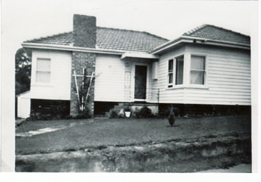
... 1950's house... October 2009. salisbury avenue blackburn no 27 1950's house ...Collected at a Heritage Week Workshop at Blackburn Library on 5th October 2009.Black & white photograph Turner home at 27 Salisbury Ave Blackburn showing a view of the back garden in 1958salisbury avenue blackburn no 27, 1950's house -
 Whitehorse Historical Society Inc.
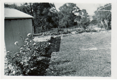
Photograph, Turner Home in Salisbury Ave Blackburn, 1958
... 1950's house...'s house retarding basin ...Collected at a Heritage Week Workshop at Blackburn Library on 5th October 2009.Black & white photograph Turner home 26 Salisbury Ave Blackburn showing view of back garden looking to the retarding basin.salisbury avenue blackburn no 27, 1950's house, retarding basin -
 Whitehorse Historical Society Inc.
Photograph, Turner Home in Salisbury Ave Blackburn, 1958
... 1950's house... October 2009. salisbury avenue blackburn no 27 1950's house ...Collected at a Heritage Week Workshop at Blackburn Library on 5th October 2009.Black & white photograph Turner home at 27 Salisbury Ave Blackburn showing view of front garden in 1958.salisbury avenue blackburn no 27, 1950's house -
 Whitehorse Historical Society Inc.
Photograph, Turner Home in Salisbury Ave Blackburn, 1957
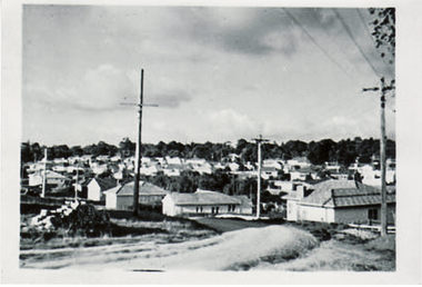
... 1950's house...'s house ...Collected at a Heritage Week Workshop at Blackburn Library on 5th October 2009.Black & white photograph Turner home at 27 Salisbury Ave Blackburn showing view looking from Middleborough Road to Salisbury Avenue.salisbury avenue blackburn no 27, 1950's house -
 Whitehorse Historical Society Inc.
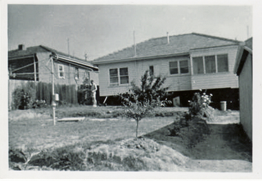
Photograph, Green Family Home, c1962
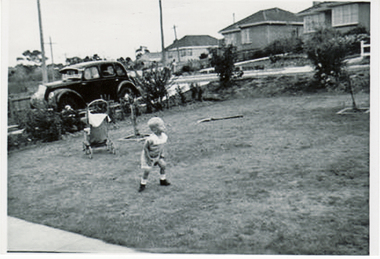
... 1950's house... elmhurst road 41 1950's house morris car 1948 8-40 ...Collected at a Heritage Week Workshop at Blackburn Library on 5th October 2009.Black & white photograph Green Family home at 41 Elmhurst Road Blackburn showing Scott Green playing on the front lawn. A 1948 Morris 8-40 is shown in the drive.green shirley, blackburn elmhurst road 41, 1950's house, morris car 1948 8-40 -
 Whitehorse Historical Society Inc.
Photograph, Green Family Home, 1961
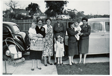
... 1950's house... 41 1950's house ...Collected at a Heritage Week Workshop at Blackburn Library on 5th October 2009.Black & white photograph Green Family home at 41 Elmhurst Road Blackburn showing Morris car ( Np3586) and the Green Family on Mother's Day in 1961. Left to right Scott Green in Shirley Greens arm; Iris Campbell; Elsie Davis -grandmother; Cherie Green; Judith Hutchenson - sister in law; with Glen Hutchenson in her arms; and Ellen Green Mother-in-law.green shirley, blackburn elmhurst road 41, 1950's house -
 Whitehorse Historical Society Inc.
Photograph, Green Family Home, c1962
... 1950's house... blackburn elmhurst road 41 1950's house ...Collected at a Heritage Week Workshop at Blackburn Library on 5th October 2009.Black & white photograph Green Family home at 41 Elmhurst Road Blackburn showing the front garden of the home.green shirley, blackburn elmhurst road 41, 1950's house -
 Whitehorse Historical Society Inc.
Article, Neighbours Oppose Subdivision Plan
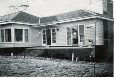
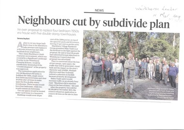
... Neighbours are opposed to the removal of a 1950's house... Plan Neighbours are opposed to the removal of a 1950's house ...Neighbours are opposed to the removal of a 1950's house.Neighbours are opposed to the removal of a 1950's house to be replaced by 5 double-storey townhouses at 124 -126 Blackburn Rd which would require removal of 39 of the 45 trees on site.Neighbours are opposed to the removal of a 1950's house.blackburn, whitehorse planning scheme, blackburn road blackburn nos. 124 -126, blackburn village residents' group -
 Kiewa Valley Historical Society
Photo - Bogong Village huts
... Bogong Village was used between the 1930's -1950's... at Bogong Village Bogong Village was used between the 1930's -1950's ...Bogong Village was used between the 1930's -1950's by S.E.C.V. to house workers and their families on the Hydro Electricity SchemeState Electricity Commission of Victoria (S.E.C.V.) construction of the Kiewa Hydro Electric Scheme. Housing for workersBlack and white photograph of House Number 1 at Bogong Villagebogong village, secv, bogong huts -
 Kiewa Valley Historical Society
Folder - Early Photos of Mt Beauty
... Mt Beauty township was built during the 1950's to house... during the 1950's to house the employees of the State Electricity ...Mt Beauty township was built during the 1950's to house the employees of the State Electricity Commission working on the Kiewa Hydro Electric Scheme. After the completion of the Kiewa Hydro Electric Scheme many houses were sold and the public buildings handed over to the Alpine Shire. Mt Beauty has always been a tourist destination especially with its proximity to the ski fields at Falls Creek.This folder contains many early photos of Mt Beauty showing the construction town during its development during the Kiewa Hydro Electric Scheme and its early days of tourism. A3 size black plastic folder with clear plastic sleeves holding early black & white photos of Mt Beauty township. Also included are: 1. 3 foolscap pages -Nov., 1953 Kiewa Hydro-Electric Scheme Progress. 2. SECV Drawing Plan (No. K6242) of Mt Beauty House - 3 angles and floor plan, English Pre-cut Type 3B.ILA with note that all houses with prefix 3B are similar. 3. Orange, black and white pamphlet "Welcome to Kiewa" 4. Tourist postcard 'fold-up' of 11 postcards "Mt Beauty and the Kiewa Scheme, Victoria 5. Drawing Plan of 'Mt Beauty Housing. Use of Prefabricated Cubicles for Houses. Type C.1 6. Drawing Plan of 'Kiewa Scheme Mt Beauty Housing Type "G". 7. 5 pages on "Twelve Tips on Caring for Old Buildings 8. Booklet advertising Mt Beauty housing for sale including activities available in the area. (1960's) 9. List of Photos from SECV held by KVHS Some photos have handwritten labels mt beauty. secv. kiewa hydro electric scheme.tourism. housing. construction town. falls creek. -
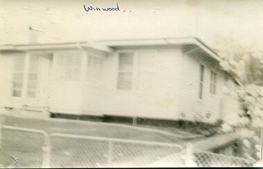 Kiewa Valley Historical Society
Photographs- Original S.E.C.V. home designs in Mt Beauty – Set of 6 black and white photographs
... ) from the 1930’s to the 1950’s to house workers on the Kiewa... Electricity Utility Commission (SEC) from the 1930’s to the 1950’s ...The townships of Mount Beauty and Bogong Village were constructed by the Victorian State Electricity Utility Commission (SEC) from the 1930’s to the 1950’s to house workers on the Kiewa Hydro Electric Scheme. At its peak the Kiewa Scheme employed around 4000 people. Although the towns were built as temporary accommodation for the workers and their families, many stayed and even retired there after the scheme had finished. The Bright Council, now the Alpine Shire took over the control of the township in 1960 and today Mount Beauty is one of the most complete company towns in Victoria.The SECV provided several standard designs for the housing of workers and management in Mt Beauty. At the completion of the scheme the housing was retained and Mount Beauty now exists as one of the best examples of a company town in Victoria.There are many examples of the original houses remaining around the town. This is significant as the houses were only built as temporary accommodation and still remain functional after over 60 or more years of use.Set of 6 black and white photographs of original SECV temporary house designs in Mt Beauty.Written in blue ink on front of photos 1. Winwood 2. Winwood 3. K Type 4. K Type 5. English Precut 6. Cube mt beauty houses, secv housing -
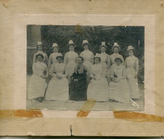 Kiewa Valley Historical Society
Photographs – Group of 3 old sepia photographs, 2 of women in period costume and 1 of group of nurses from Sunbury sanatorium
... by the SECV from the 1930’s to the 1950’s to house workers... by the SECV from the 1930’s to the 1950’s to house workers ...Europeans arrived in the Kiewa Valley in the 1830s and 40s. Following the drought of 1838-44 seeking out the rich pastures in the fertile Kiewa Valley. . The next major increase in population was as a result of the Kiewa Hydro Scheme. The beginning of construction of the Kiewa Hydro-electric scheme in the late 1940s introduced changes and led to the enlargement and improvement of local roads and the townships of Mount Beauty and Bogong Village were constructed by the SECV from the 1930’s to the 1950’s to house workers on the Kiewa Hydro Electric Scheme. At its peak the Kiewa Scheme employed around 4000 people from all walks of life and as many cultures.The influx of European migrants to work on the Hydro Scheme along with their rich cultural backgrounds, all played a major part in establishing the history of the area and in shaping the future character of the Mount Beauty, the Kiewa Valley and Falls Creek areas. Photographs may depict descendants, family or friends of early settlers or workers in the Kiewa Valley region.1. Sepia photograph, mounted on heavy buff card with yellowing marks from sticking tape across the bottom of the photograph. Photograph is of a group of nurses taken at the Sunbury Sanitorium 2. Sepia photograph mounted on heavy buff card with yellowing marks from sticking tape at top and bottom of photo. Mark from drawing pin in centre top of photo. Photograph is of a middle aged woman posing dressed in period costume 3. Sepia photograph mounted on heavy buff card with yellowing marks from sticking tape at top and bottom of photo. Mark from drawing pin in centre top of photo. Photograph is of an older woman posing dressed in period costume sepia photos; nurses; kiewa valley; sunbury sanitorium; period costume -
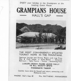 Halls Gap & Grampians Historical Society
Flyer - B/W, C 1931
... a bowling green next to the cafe. In the late 1950's Grampian House... to the cafe. In the late 1950's Grampian House Guest House was leased ...On Dec.25, 1940 Sylvia Vyanna Morgan passed away. Dorothy had married Roy Warren from Myrtlebank Guest House and Thomas had married Edna Kennedy. In 1942 Nina married Arthur Mangle and in 1946 built Mountain Grand Guest House opposite Grampian House. By 1950 Morgan decided to sell Grampian House and moved to Stawell. The new owners of Grampian House were Fredrick Charles Kingston, a successful bus company operator from Stawell and his daughter Ethel May Mathews who together with her husband Des built the adjoining famous Kookaburra Cafe in 1946. Fredrick had also built a bowling green next to the cafe. In the late 1950's Grampian House Guest House was leased to several people including Mr & Mrs. Hudousek, Paul Loren and people with surname Virtue. It was during this time that the front veranda and pergola were demolished and the house modernised. Nina Mangle and her two sons Arthur & Charles purchased the property and operated it as an overflow for Mountain Grand Guest House. Well known artist Neil Douglas operated a studio on the premises and Horsham identities Evan and Barbara Mackley housed a museum of furniture and artefacts on the site. Advertisement and photo of Grampian House. accommodation, guesthouses, accommodation, grampian house -
 City of Moorabbin Historical Society (Operating the Box Cottage Museum)
Photograph, Black & White, 'Oak Bank' later 'Whitehouse' Ann St. McKinnon c1920, c1960
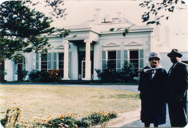
'Oak Bank ' , in Ann Street McKinnon, was originally owned by Mr Robert Smith. The house was later renamed 'The Whitehouse' and was still in use as a General Hospital in the 1950's, known as the Ann Street Hospital.. This small hospital handled some Surgery, Midwifery and general Medical cases from the fast growing Bentleigh / McKinnon area. As time progressed the Hospital became too small, and was unable to meet new medical standards When Moorabbin Community Hospital opened c1974 in Centre Road East Bentleigh, the Ann St Hospital closed. The Moorabbin Hospital is now a campus of Monash Medical Centre Clayton. 'The Whitehouse' was used as a general Hospital for the residents of McKinnon, Bentleigh, and Ormond for many years during the 20thC.Colour photograph showing Mrs John Marriott ( nee Ann Smith) , her son Fred Marriott standing outside 'The Whitehouse' undated ? c1960Back ; Handwritten informationoakbank house mckinnon, whitehouse mckinnon, ann street general hospital, moorabbin community hospital, monash hospital clayton, smith robert, lees seedling growers ltd. thomas street mckinnon,mith j l; smith mary ann, stanley helen, smith vic, chaff cutter, horse drawn carts, toll gates brighton, motor cars 1900, steam engines, early settlers, bentleigh, mckinnon, parish of moorabbin, city of moorabbin, county of bourke, moorabbin roads board, shire of moorabbin, henry dendy's special survey 1841, were j.b.; bent thomas, o'shannassy john, king richard, charman stephen, highett william, ormond francis, maynard dennis, market gardeners, vineyards, orchards -
 City of Moorabbin Historical Society (Operating the Box Cottage Museum)
Domestic object - Kitchen equipment, gas-fuelled flat iron, c1900 - 30
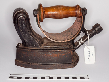
Sad-irons or "solid" irons were made by blacksmiths and used to smooth out material by pressing the hot iron over it. A piece of sheet -iron was placed over the kitchen fire and the irons placed on it could be heated whilst remaining clean of ash.. The women used 2 irons - one heating while the other was used. Thick cloth or gloves protected their hands from the hot irons. The handle was removed from the cool iron and re- attached to remove the hot iron from the fire. The cool iron was replaced on the fire or stove to heat again. These irons were cleaned with steel wool to prevent them marking the material. If the iron was too hot the material would scorch. Most homes set aside one day for ironing and some large households had an ironing room with a special stove designed to heat irons. However, most women had to work with a heavy, hot iron close to the fireplace even in summer. Thomas Fletcher (1840-1903). By 1880s he had a gas appliance manufactory in Thynne Street, Warrington. By 1895 the company had become Fletcher Russell and Co Gas Engineers, his firm having merged with Alexander and William Russell of Pendleton Iron Works. Circa 1950, the firm merged into Radiation Ltd which was later acquired by 'TI New World'; 1902: Fletcher, Russell & Co. Ltd., Palatine Works, Warrington In 1880 gas -fuelled irons were connected by rubber tubing to the gas light-fittings of the house or to gas canisters. However , not many houses had access to a gas supply until much later and this iron was popular in 1920’sThese sad irons remind us of the difficult circumstances experienced in their daily routines by the pioneers and early settlers of Moorabbin Shire The family of Miss M Curtis were early settlers in Moorabbin Shire.A gas-fuelled flat iron, made in USA , It would have been attached to a gas hose fitting that was also used at night for light in the house. There is a small chimney to allow for air and to try to control the amount of heat in the iron. A 'shield' is under the leather covered handle to protect the user's hand from the heat, however it is made of copper metal - a heat conductor.FLETCHER RUSSELL CO. / LIM/ PATENT/ WARRINGTON on right side of handle 'Registered' on left side of handle ' Fletcher Russell Co L / Warrington, Manchester / & London.sad iron, kitchen equipment, fletcher russell co. ltd., england, warrington, manchester, pioneers, early settlers, market gardeners, sewing, craftwork, clothing, moorabbin, brighton, bentleigh, fireplaces, stoves, domestic gas supply, gas-light, gas cannisters -
 Mortlake and District Historical Society
Photograph - The old vicarage, F.B.W. Stevenson, Photographer (on back)
Shows a bluestone house surrounded by lush, well-developed garden. House is in good order with 4 chimneys, a porch and water-tank. To the left, partially obscured by the shrubbery stands the bearded Rev.Wagg with hat. To the right is a girl around ?10 years old, with parasol and hat in her hands. This was Mortlakes' Anglican Vicarage from c. 1886 to c.1916 when present one was built next to St.James church in Shaw Street. House stood in Sagnol's paddock (Waggs Lane) until 1950's when it was demolished reportedly by a group of boys using dynamite!) Rev. Wagg was a long-serving and well-regarded Anglican minister who served Mortlake from 1886 to1916. Wagg's Lane takes its name from his former residency there. A new Vicarage was built c.1916 next to the church. The old vicarage was reduced to rubble reputedly by boys using gelignite in the 1950's; the remains can be seen in the paddock on Wagg's Lane.Sepia rectangular photograph on cardboard backingWritten on the back: The Vicarage Mortlakechurch, anglican, mortlake, wagg, lane, waggs -
![Sign, [14/8/1937]](https://victoriancollections.net.au/media/collectors/4f729f5b97f83e0308601618/items/4f72acc197f83e030860399a/item-media/4f72acc197f83e030860399c/item-fit-380x285.jpg) Mortlake and District Historical Society
Mortlake and District Historical SocietySign, [14/8/1937]
Outbreaks of poliomyelitis were common up until the 1950's when vaccine became available. The cause was not known and management was difficult - paralysis in varying degrees was the usual outcome. Public concern was high especially concerning children. One of the most significant Australians to suffer from this disease, was Alan Marshall (1902 -1984) who was born in Noorat, 15 kilometres from Mortlake. He wrote an account of his boyhood after he was struck down by the disease, in the internationally acclaimed 'I can jump puddles' (1955).Rectangular piece of calico'Shire of Mortlake. INFANTILE PARALYSIS. 1. Parents or Guardians of all children aged eighteen and under coming into the Shire of Mortlake from the Metropolitan or any other area affected with Infantile Paralysis, MUST REGISTER such children immediately either personally or by post at the Shire Hall, Mortlake. 2. Parents or Guardians of such "registered" children are requested to keep them away from all public gatherings and from all contact with other children for a period of Twenty-one days, and in the event of any illness to consult a Doctor immediately. 3. Residents of the Shire with children living in the house are requested in their own interests, not to take into their homes, or allow their children to have contact with, any "registered" child. 4. The following particulars are required upon registration:- Name, Age, Sex, Local Address, Metropolitan School, Grade, Metropolitan Address, Date of Leaving Metropolitan or affected area. Registration forms may be obtained at the Shire Hall, Mortlake, and at all Post Offices within the Shire. By Order, N.TURNBULL, Shire Secretary. MORTLAKE, 14/81937. ' -
 Kiewa Valley Historical Society
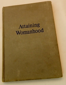
Book - Reference, Attaining Womanhood, First Published in 1953
Published by George Allen & Unwin, Ltd., Ruskin House, Museum Street, London. There is no clue as to the owner of this bookThis book provides a factual scientific account of sex and human reproduction as taught in the 1950's. It is particularly interesting to compare the expected conduct of young women in this era with the standards of today.A grey, hard covered text book with the title "Attaining Womanhood" in blue print on the front cover and "Attaining Womanhood George Corner" on the spine of the book Written by George W. Corner M.D., Director, Dept. of Embryology, Carnegie institute of WashingtonOn the first page is the title "Attaining Womanhood" and below this "A Doctor Talks to Girls About Sex". Written by George W. Corner, M.D. and an introduction by Dr. Eustace Chessersex education, book, school, reproduction -
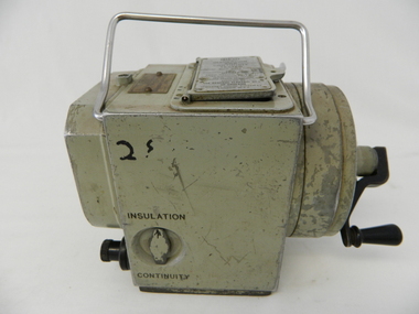 Kiewa Valley Historical Society
Tester Direct Current, mid 1900's
This tester was used between 1950 and 1980's. As part of the Occupation, Health and Safety requirements, equipment used to monitor the performance of electricity producing generators, regularly, hand held testers were used to check the insulation and the "earth" pin were up the the required operational levels. As the generators and their ancillary monitoring equipment was spread over a large area and cumbersome to service small hand held devices were required. These had to always be safe for the user to operate. A selected range of high quality meters were recalibrated every two years in the Meter and Calibration Laboratory at Yarraville(near Melbourne) This meter is very significant to The Kiewa Hydro Electricity Scheme because it was an integral part of maintaining the electricity producing water driven generators of the power stations. The reason why this meter was so essential is that provided the safety check on equipment used to monitor each Hydro Generator that they were complying within the grid network parameters. Grid parameters are set so that if there is an electrical fault on the system, that fault can be attended to with a very small change in the output stability of each generator. It is essential that the voltage of the network remain within the set limits. Generators are at Dartmouth, Mackay, Clover, West Kiewa, Yarrawonga, Cain Curran and three Power Stations in the Thornton area.This hand driven current generator produces 500 volts by winding the handle(on funnel curved side) to keep the voltage constant(one minute per test). The whole body is made from caste aluminium. One of the functions of this meter is to test the isolation resistance of any equipment being tested. This is to see if that equipment is safe to handle(no electrical shocks). The second function is to test the earth pin of any portable electrical equipment. The turn key on one side can direct which function is required(marked insulation or continuity). On the top side(enclosed in a glass fronted marked scale) is a continuity scale(top) and an insulation scale(bottom). This is covered , when not in use by "flip up" lid with manufacturer's details and name of the instrument. Opposite the winder are two screw tight knobs. One marked earth(left side) and one marked line(right side). On the top and next to the glass windowed scales in a post manufacture SEC Vic equipment equipment ID number. For carrying purposes there is chromed steel (fold together) handle.The bottom of the unit has two metal "feet" 150mm long by 114mm wideManufacturer's details on top side "MEG" underneath "INSULATION AND CONTINUITY TESTER" below this "constant 500 VOLT pressure" below this "REGISTERED MEG MEGGER TRADE MARK" below this "REG DESIGN NO. 690326" below this "UNITED KINGDOM PATENT Nos. 193746, 197178, 198182, 202062, 202398, 204649, 350715" below this "SUPPLIED BY THE GENERAL ELECTRIC Co. Ltd OF ENGLAND" below this "MAGNET HOUSE, KINGSWAY LONDON W.C.2" 'sec vic kiewa hydro scheme, alternate energy supplies, alpine feasibility studies temperature, rainfall -
 Kiewa Valley Historical Society
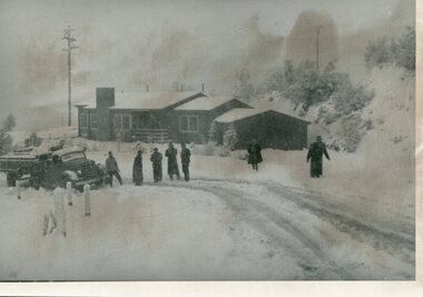
Photograph Bogong, Bogong Township Circa 1950, circa 1940s to 1950s
The Bogong Village was originally constructed (1937-1940) by the State Electricity Commission to house, engineers and construction workers working on the Kiewa Hydroelectric Scheme. These workers were initially settled in 26 houses and were mainly of European heritage. At the completion of the scheme, in the 1960's, the village was opened to public/tourism use. This photograph shows the village before beautification for tourism was introduced and "bare bones" homes and village usage existed.This photo clearly presents a period of restricted human occupation of a very fragile Alpine environment(up to 4000 workmen involved). This was the beginning of a planned and controlled form of sustainable tourist orientated development of the Victorian Alps and high plains region. The Bogong Township was the base camp for workers employed by the State Electricity Commission. After the construction phase was completed, the planning and controls originating from this period have been modified to allow a greater public access of this unique environment.Photograph of a framed glass enclosed black and white photograph of the Bogong settlement Paper details "KodakXtraLife paper" on back of photo. bogong village, bogong township, sec alpine constructions, hydro, kiewa scheme -
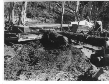 Kiewa Valley Historical Society
Photograph, logging at McKay Creek, c1950's
This photograph was probably taken at the site of McKay Creek Power Station. Excavation of this site did not commence until 1951 but road access(a narrow track) was provided in 1948 and widened in 1954. The logs would have been milled for timber at the State Electricity Commission's mill at Howman's Gap and thus provided a much needed source of timber for construction of camps and houses as there was a general of shortage of this commodity. Because of trouble with landslides in this area, a decision was made to place the machine hall of the power station underground instead of on the surface. Restricted financial resources and the repositioning of the power station retarded construction activities and it was not completed until early 1961.. An excellent pictorial record of the general working conditions, type of machinery and vehicles in use in the 1950/s.Black and white photograph showing logging equipment, fallen logs.Handwritten on the back of the photograph "Logging at McKay Creek)logging, mckay creek, timber, machinery -
 Eltham District Historical Society Inc
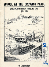
Book, School at the crossing place : Lower Plenty Primary School no. 1295, 1874-1974 / W.F. Henderson, 1974c
23 pages including information on inside covers. Text with black and white illustrations and photographs and map. Contents: Crossing Place Need for a school Residence for the teacher Closure A View of Lower Plenty 1918 Moving day at the Village The Golf Club Depression 1931 Vandals Electricity Grass Fires Cows at School Mothers' Club Women's liberation 1950's Lower Plenty after 1945 Swimming Pool - drowned dreams Long Grass - snakes - meadow hay - Fire Brigade The Royal Visit 1954 School Band Community Centre Our School Hall Trees and Gardens The Library Education 1874-1974 A Teacher's View The Second generation - children of ex-pupils (photo with names) The Third generation - Grandchildren of ex-pupils (photo with names) Head Teachers (list with dates) The Staff 1974 (photo with names) The sketch on the cover shows the Lower Plenty Bridge, toll house and the Plenty Bridge hotel, both no longer there. The bridge is listed in the Banyule Heritage Study and has recently been restored by Banyule Council as a pedestrian bridge - NL 137 March 2001 Paperback; [24] p. : ill. ; 25 cm.lower plenty, state school no. 1295, lower plenty primary school -
 Eltham District Historical Society Inc
Photograph, Woodburn residence, mudbrick adobe (1949), Eltham Heritage Tour, 24 May 1992, 24/05/1992
ELTHAM HERITAGE TOUR The Society excursion on 24th May 1992 was arranged by David Bick, leader of the team carrying out the Shire's heritage study. David selected a number of sites or buildings identified in the study, some of them lesser known components of the Shire's heritage. The tour commenced at the Eltham Shire Office at 10.00 am. Travel was by private car and mini-bus with stops at about twelve locations for commentary by David.It included a short walk in Hurstbridge and lunch at Kinglake. Highlights of the tour included: - 10 am Leave from Shire Offices - 3 Important Trees - A Physical Link to Eltham's First Settlers - Toorak Mansion Gates - A Surviving Farm House - An Intact Circa 1900 Main Street - First Settlers - Gold Miners, and Timber-getters - An Early Hotel - A Pioneering Homestead - Changing Eltham Shire - 20th Century - 4 pm Afternoon Tea and Finish Tour Extract from ELTHAM CULTURAL HERITAGE TOUR (Newsletter No. 85, July 1992, by Bettina Woodburn) "In some respects Eltham is a 'back-water' and it has its own distinctive flavour. On the outskirts the homes date from the 1960's, 70's and 80s with a sprinkling of 'earth homes', mud-brick or pise, rammed dirt. Crossing Main Road into Beddoe Street and Thompson Crescent a very pleasant drive past pines and old fence lines, front lawns unfenced, the occasional ·old farm building, we eventually looked down on a huge circular roof of a 1992 adobe home. Other distinctive places included the Pauline Toner Butterfly Reserve, Gordon Ford's splendid garden at Fulling in Pitt Street, cypress hedges and old houses in Bridge Street and in every direction Eltham's special feature - a totally treed horizon. We were now in the part of the Shire closest to Melbourne - Montmorency - not on the way to anywhere, with no through road going across it, developed in the 1950's and 1960's with conventional gardens, now converted to native plants. The rail looped between Greensborough and Eltham and a shopping street (Were Street) served the area, growing up the hill from the station. It was a typical outer Melbourne suburb with lawns and roses with patches of originality. The shopping precinct still has 1950 characteristics - walls which sloped back, projecting roofs, the original shop fronts are nearly all tiled below the old windows. There's an air of past times about the School, the Dairy, the Butcher's (now a milk bar) and the Castlemaine stone face of the Commonwealth Bank. The final stop for the tour was at the mud-brick Woodburn residence, adobe of 1949 with additions. After War Service, Bill Woodburn had commenced an Architecture course at Melbourne University and after second year in the Christmas vacation, with his wife, Betti, built the two bedroom house - with amazing saving of costs. In the three and a half months they made over 3000 bricks (external walls 18" x 12" x 4", internal walls 12" x 9" x 4"), sifted top soil for mortar and laid them, on concrete foundations and slab floor, made all the structural window frames, door frames and roof members to carry 'super six' asbestos sheets, laboured for the electrician and plumber, did all the glazing and, still without electricity, moved in in March 1949. Rooms have been added, at first with glass walls, later using concrete blocks, to accommodate three daughters and a son. The house not only grew from the earth, but also with the family."Record of the Society's history and activities and highlighting various aspects of the Heritage Study undertaken by David Bick used to create the future heritage overlay for the Shire of Eltham and later Nillumbik Shire.Roll of 35mm colour negative film, 4 stripsKodak Gold 100 5095shire of eltham historical society, activities, heritage tour, woodburn house -
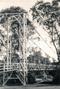 Eltham District Historical Society Inc
Photograph, Pedestrian suspension bridge over the Yarra River at Lower Plenty
Odyssey House drug rehabilitation centre in Bonds Road, Lower Plenty is a distinctive landmark, especially when viewed from across the Yarra at Templestowe. It was built in the 1950’s as a seminary for the Blessed Sacrament Fathers. Because of the poor and circuitous road access, a suspension footbridge was built across the river. As well as providing easy access for the priests residents of Templestowe could attend services at the seminary. The bridge is now part of the Yarra Trails system.Two black and white photographs of footbridge over Yarra River, part of the Ruffey Trail just off the Main Yarra Trail near the former seminary (now Odyssey House) Lower Plentybridges, yarra river, odyssey house, bonds road, lower plenty, seminary, blessed sacrament fathers -
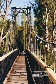 Eltham District Historical Society Inc
Photograph, Pedestrian suspension bridge over the Yarra River at Lower Plenty
Odyssey House drug rehabilitation centre in Bonds Road, Lower Plenty is a distinctive landmark, especially when viewed from across the Yarra at Templestowe. It was built in the 1950’s as a seminary for the Blessed Sacrament Fathers. Because of the poor and circuitous road access, a suspension footbridge was built across the river. As well as providing easy access for the priests residents of Templestowe could attend services at the seminary. The bridge is now part of the Yarra Trails system.Colour photograph of footbridge over Yarra River, part of the Ruffey Trail just off the Main Yarra Trail near the former seminary (now Odyssey House) Lower Plentybridges, yarra river, lower plenty, seminary, blessed sacrament fathers, odyssey house, bonds road -
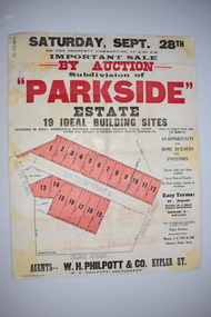 Warrnambool and District Historical Society Inc.
Original Document, H J Paynter, Advertisement "Parkside"Estate subdivision, Circa 1935
This sheet denotes an auction of land which is situated close to Albert Park on the northern part of Warrnambool. The area is complete now with homes which are a mixture of brick and concrete faced houses. The agent W H Philpott was operating in Warrnambool from the 1930's though to 1950'sThis item has local interest and significance as it records the sale of Warrnambool land.Large white paper sheet with black and red text. The auction details are at the top and down the righthand side with a map of the available blocks are coloured red and outlined in black.Parkside estate, W H Philpott & Co Kepler St , R V Philpott auctioneer,Solicitors J S Tait & son. Cramer Street, Nelson Street McConnell Street.warrnambool, mcconnell street warrnambool